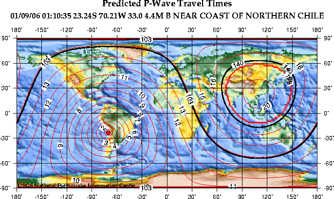
Cette carte montre la durée du trajet théorique, en minutes, pour les ondes P du séisme. Les lignes noires épaisses montrent la distance approximative de la zone d'ombre des ondes P (103-140 degrés).
|
villes |
Distance |
Durée du trajet |
Temps d'arrivée |
Phase |
|
Lima, Peru |
12.85 |
3:00.3 |
1:13:35.2 |
Pn |
|
San Juan, Puerto Rico |
41.65 |
7:45.1 |
1:18:20.1 |
P |
|
Palmer Station, Antarctica |
44.70 |
8:09.7 |
1:18:44.7 |
P |
|
Miami, Florida |
49.66 |
8:48.3 |
1:19:23.3 |
P |
|
Mexico City, Mexico |
50.95 |
8:58.1 |
1:19:33.1 |
P |
|
Brownsville, Texas |
55.53 |
9:31.8 |
1:20:06.8 |
P |
|
Knoxville, Tennessee |
60.54 |
10:06.9 |
1:20:41.9 |
P |
|
Washington, D.C. |
62.13 |
10:17.7 |
1:20:52.7 |
P |
|
Philadephia, Pennsylvania |
63.02 |
10:23.7 |
1:20:58.7 |
P |
|
New York, New York |
63.71 |
10:28.3 |
1:21:03.3 |
P |
|
St. Louis, Missouri |
64.38 |
10:32.6 |
1:21:07.6 |
P |
|
Boston, Massachusetts |
65.24 |
10:38.2 |
1:21:13.2 |
P |
|
Wichita, Kansas |
65.82 |
10:42.0 |
1:21:17.0 |
P |
|
Albuquerque, New Mexico |
67.50 |
10:52.7 |
1:21:27.7 |
P |
|
Bangor, Maine |
67.71 |
10:54.1 |
1:21:29.1 |
P |
|
Ottawa, Canada |
68.50 |
10:59.0 |
1:21:34.0 |
P |
|
Golden, Colorado |
70.66 |
11:12.3 |
1:21:47.3 |
P |
|
Duluth, Minnesota |
72.43 |
11:23.0 |
1:21:58.0 |
P |
|
Los Angeles, California |
73.02 |
11:26.5 |
1:22:01.5 |
P |
|
San Francisco, California |
78.03 |
11:55.2 |
1:22:30.2 |
P |
|
Seattle, Washington |
84.77 |
12:30.9 |
1:23:05.9 |
P |
|
Wellington, New Zealand |
92.02 |
13:05.4 |
1:23:40.4 |
P |
|
Honolulu, Hawaii |
96.09 |
13:24.1 |
1:23:59.1 |
P |
|
London, England |
96.31 |
13:25.0 |
1:24:00.0 |
P |
|
Rome, Italy |
100.00 |
13:41.5 |
1:24:16.5 |
Pdiff |
|
Bergen, Norway |
103.08 |
13:55.2 |
1:24:30.2 |
Pdiff |
|
Nairobi, Kenya |
105.12 |
14:04.2 |
1:24:39.2 |
Pdiff |
|
Anchorage, Alaska |
105.28 |
14:04.9 |
1:24:39.9 |
Pdiff |
|
Moscow, Russia |
118.91 |
15:05.4 |
1:25:40.4 |
Pdiff |
|
Agana, Guam |
145.50 |
19:33.9 |
1:30:08.9 |
PKPbc |
|
Tokyo, Japan |
151.24 |
19:43.3 |
1:30:18.3 |
PKPdf |
|
Kathmandu, Nepal |
157.48 |
19:52.0 |
1:30:27.0 |
PKPdf |
|
Beijing, China |
162.45 |
19:57.6 |
1:30:32.6 |
PKPdf |
Data
      6 SEP 2001  (249)

     ot  = 01:10:35.90   +/-   1.04              NEAR COAST OF NORTHERN CHILE
     lat =     -23.239   +/-   18.8
     lon =     -70.211   +/-   12.7              MAGNITUDE 4.4 (GS)
     dep =        33.0  (normal depth)

     30 miles (50 km) NNE of Antofagasta, Chile (pop 243,000)
     95 miles (155 km) WSW of Calama, Chile (pop 121,000)
     205 miles (330 km) S of Iquique, Chile
     710 miles (1140 km) N of SANTIAGO, Chile

     nph =   14 of  14    se = 1.37                                    B

     error ellipse = (183.5, 93.5,  0.0;  0.0,  0.0,  0.0; 24.9, 16.7,  0.0)

 mb = 4.4 ( 10)  ML = 0.0 (  0)  mblg = 3.4 (  3)  md = 0.0 (  0)  MS = 0.0 (  0)

 sta  phase     arrival     res   dist azm    amp  per mag     amp  per mag  sta
 LVC  eP      01:11:00.76   1.9    1.4  63                                   LVC
 LPAZ eP      01:12:22.92   0.9    7.2  16 d:2.3+2     6.7X L:5.2-2 .70 4.0X LPAZ
                                           g:3.1-2 .70 3.4
 BDFB eP      01:15:30.57  -1.0   22.2  74 g:1.1-2 1.0 3.6  b:1.3+1 1.0 4.3  BDFB
 PTGA eP      01:15:51.18  -2.2   24.5  25 g:5.5-3 .90 3.4  b:3.3+0 .61 4.1  PTGA
 JCT  eP      01:20:45.30   0.2   60.5 331 b:3.1+0 .39 4.8                   JCT
 WVT  eP      01:20:48.89  -1.9   61.4 344 b:4.5+0 .65 4.7                   WVT
 MIAR eP      01:20:51.61  -0.9   61.6 338 b:3.6+0 .52 4.7                   MIAR
 TUC  eP      01:21:32.07   1.2   67.5 323 b:2.2+0 .88 4.3                   TUC
 DBIC eP      01:21:47.64  -1.4   70.4  73 b:2.9+0 .46 4.6                   DBIC
 DUG  eP      01:22:14.67   1.3   74.5 327 b:1.7+0 .82 4.1                   DUG
 HWUT eP      01:22:16.63   0.5   75.0 329 b:2.8+0 .65 4.4                   HWUT
 BGCA eP      01:23:37.98   0.4   90.8  85 b:5.0-1 .63 4.0                   BGCA
 AAK  ePKPdf  01:30:12.06   0.4  145.0  48                                   AAK
 TKM2 ePKPdf  01:30:13.35   0.6  145.6  47                                   TKM2


 Generated 2001 SEP  6 at 18:34 UTC
URL: http://neic.usgs.gov/neis/bulletin/P0109060110.html